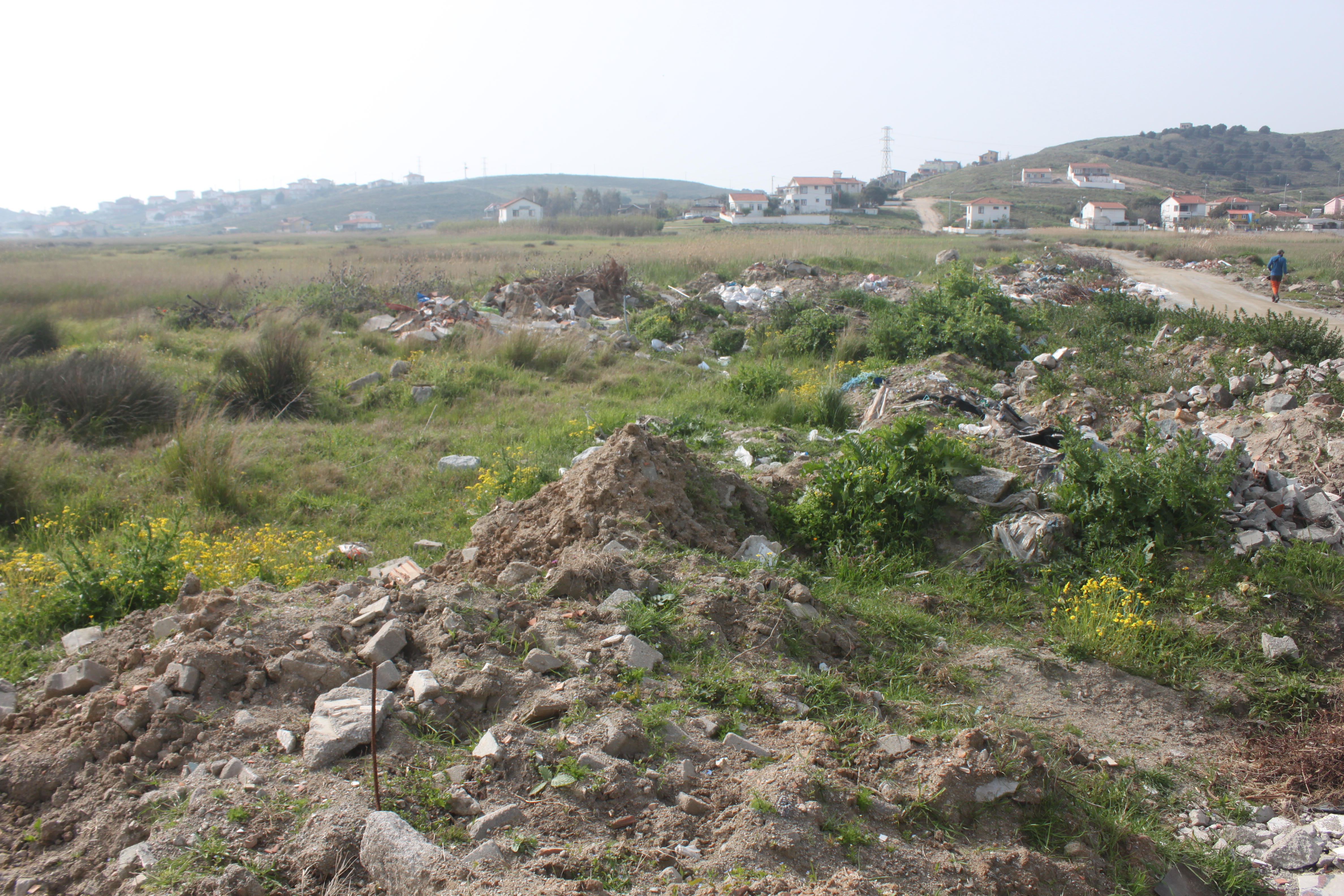
Altınkum Reedbed is located on Avşa Island, 3 km southeast of the centre, at Marmara Adalar Municipality. It is the largest of the two wetlands of the island, covering 16.45 ha. It is a coastal wetland, and main water sources are precipitation and underground water. On the surface it is disconnected from the sea by the car roads and settlements and approximately %50 of the original landform was degraded and transformed. Although it is defined as a ‘lake’ in the spatial plans prepared by the municipality, the wetland is threatened with expanding road constructions, and pollution resulting from solid waste dumping and debris. It was observed that the water is discharged to the sea by pipelines, probably for prevention of flood for the settlements. The dominant vegetation is Cypeus sp. and dominant habitat type is beds of large sedges (72B0), whereas Reed thickets (72A0) covers a small part. The wetland is also an important breeding and feeding site with bird species considering the limitation of water sources on the island.
Wetland data
Basic information
Wetland location:
Marine/Coastal
Wetland type:
Natural
Wetland area:
16.4 Ha
Hydrological interaction:
-
Water salinity:
Brackish (5.0-18.0 g/l)
Open water area (%):
26 - 50
Hydroperiod:
Permanent
Geographic information
Province:
Balikesir
Municipality:
Marmara Adalar
Island:
Avsa
Longitude:
27.526545 East
Latitude:
40.493339 North
Wetland condition
Wetland status (MEDWET):
3 - Original habitats/landform partially modified (10-50% untouched)
Ramsar wetland type
Type
Coverage (%)
Ts -- Seasonal/intermittent freshwater marshes/pools on inorganic soils; includes sloughs, potholes, seasonally flooded meadows, sedge marshes
51 - 75
E -- Sand, shingle or pebble shores; includes sand bars, spits and sandy islets; includes dune systems and humid dune slacks
5 - 25
Property status
Government - Municipal / Private
Activities on wetland
Activity
Intensity
401 = continuous urbanisation
Medium
440 = Storage of materials
High
501 = paths tracks cycling tracks
Medium
502 = roads motorways
Low
530 = Improved access to site
Low
701 = water pollution
Low
702 = air pollution
Low
703 = soil pollution
High
800 = Landfill land reclamation and drying out general
810 = Drainage
Low
811 = management of aquatic/vegetation for drainage
Low
860 = Dumping depositing of dredged deposits
Low
Activities on catchment area
Activity
Intensity
440 = Storage of materials
Medium
501 = paths tracks cycling tracks
Low
502 = roads motorways
Medium
530 = Improved access to site
Medium
700 = Pollution
Medium
800 = Landfill land reclamation and drying out general
Low
853 = management of water levels
Low
Impacts
Impact
Intensity
AS- = Loss of scenic value
Medium
HF- = Habitat fragmentation
High
HL- = Habitat loss
Medium
LS- = Decrease in water supply
Low
LW- = Decrease in wilderness/wildlife values
Low
VC- = Change in vegetative species composition
Low
WG- = Drainage/Reduction of water level
Low
WGT = Lowering of water table
High
Habitat types
Type
Coverage (%)
72A0 Reed thickets
5 - 25
72B0 Beds of large sedges
76 - 95
Vegetation types
Type
Coverage (%)
Floating
26 - 50
Emergent
> 95
Flora
Species
Presence status
References
Carex sp.
Cyperus sp.
Juncus acutus
Juncus maritimus
Juncus subulatus
Lemna sp.
Phragmites communis
Typha sp.
Fauna
Birds
Number of individuals
Nesting
References
Streptopelia decaocto
1-10
Possible nesting
Gallinula chloropus
1-10
Possible nesting
Acrocephalus scirpaceus
1-10
Possible nesting
Corvus monedula
10-100
Possible nesting
Delichon urbicum
1-10
Possible nesting
Hirundo rustica
1-10
Possible nesting
Parus major
1-10
Possible nesting
Passer domesticus
1-10
Possible nesting
Phylloscopus collybita
1-10
Possible nesting
Sylvia communis
1-10
Possible nesting
Amphibians
Presence status in wetland
References
Images
WWF Turkey. (2018). TrIsWet – Database of the Turkish island wetlands. Updated: 04.2024