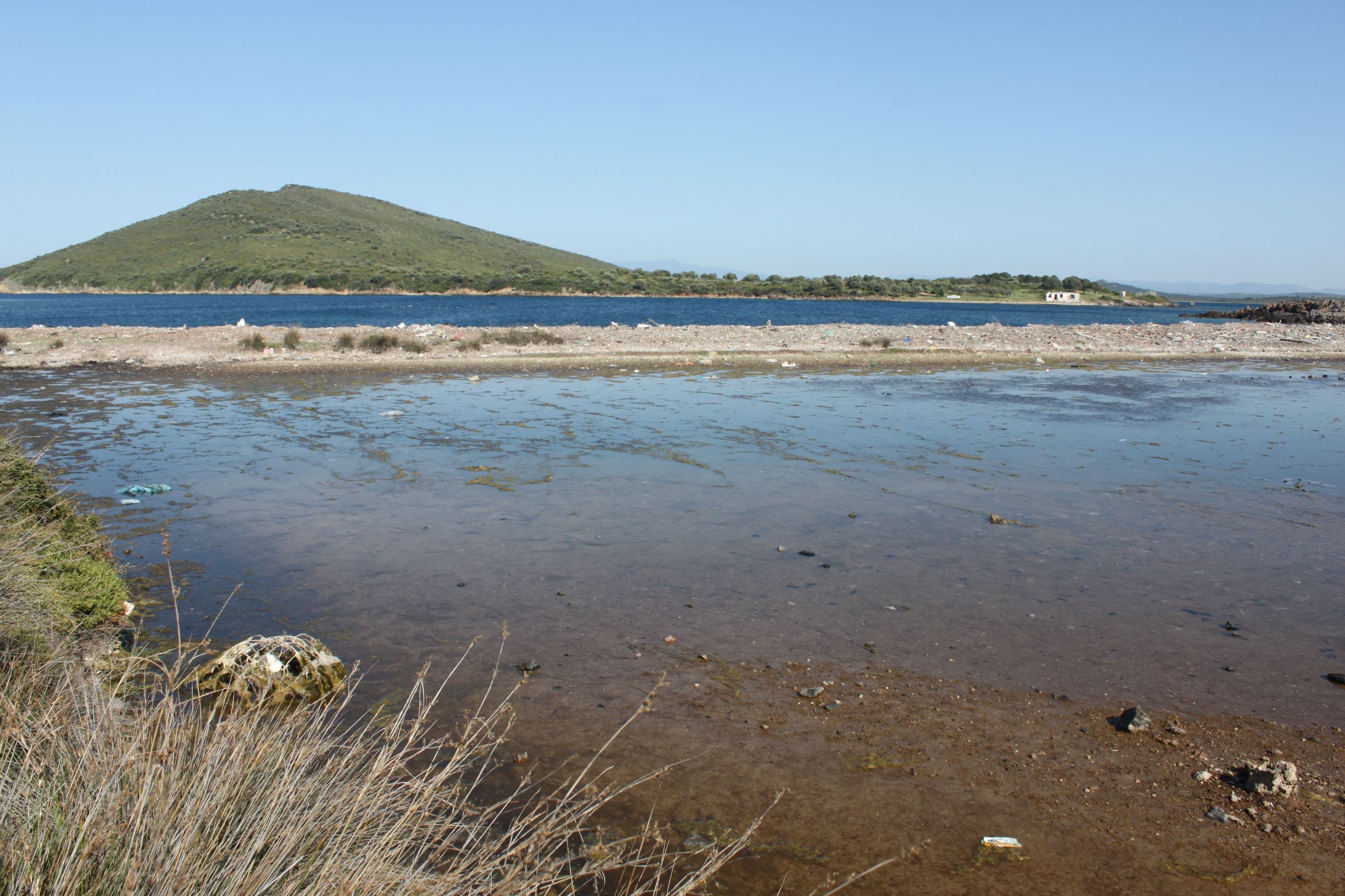
Maden Island Pond (East) is a seasonal saltwater pond located on the east coast of Maden Island at Ayvalık Municipality. It covers 0,4 ha area. Although there is no human settlement on the island, the wetland area and the coastline is heavily polluted due to solid waste, washed by the sea. The main water source for the wetland is presumably precipitation and sea water. Sarcopoterium spinosum phryganas (5420), Garrigues of Eastern Mediterranean (5340), Mediterranean salt meadows (Juncetalia maritimi) (1410), and Mediterranean salt steppes (Limonietalia) (1510) are the habitat types recorded during the field survey.
Wetland data
Basic information
Wetland location:
Marine/Coastal
Wetland type:
Natural
Wetland area:
0.4 Ha
Hydrological interaction:
-
Water salinity:
Brackish (5.0-18.0 g/l)
Open water area (%):
51 - 75
Hydroperiod:
Permanent
Geographic information
Province:
Balikesir
Municipality:
Ayvalik
Island:
Maden
Longitude:
26.595021 East
Latitude:
39.387856 North
Wetland condition
Wetland status (MEDWET):
2 - Original habitats/landform still predominant (>50%)
Ramsar wetland type
Type
Coverage (%)
E -- Sand, shingle or pebble shores; includes sand bars, spits and sandy islets; includes dune systems and humid dune slacks
5 - 25
H -- Intertidal marshes; includes salt marshes, salt meadows, saltings, raised salt marshes; includes tidal brackish and freshwater marshes
5 - 25
Property status
Government - Municipal
Protection statuses
Protection status category
Protection status subcategory
Area's name
Coverage area (%)
Legislation
National
Nature Park
Ayvalik Islands Nature Park
100
National
Natural Protected Area
100
Ecosystem services
Type of ecosystem service
Ecosystem service
Scale of Βenefit (%)
Importance
Supporting services
Provision of habitat
Activities on wetland
Activity
Intensity
700 = Pollution
High
701 = water pollution
High
703 = soil pollution
High
951 = drying out / accumulation of organic material
Medium
952 = eutrophication
Medium
Activities on catchment area
Activity
Intensity
700 = Pollution
High
703 = soil pollution
High
Impacts
Impact
Intensity
AS- = Loss of scenic value
High
LU- = Decrease in tourist/recreation potential
High
LW- = Decrease in wilderness/wildlife values
High
Habitat types
Type
Coverage (%)
5420 Sarcopoterium spinosum phryganas
5 - 25
5340 Garrigues of Eastern Mediterranean
5 - 25
1410 Mediterranean salt meadows (Juncetalia maritimi)
5 - 25
1510 * Mediterranean salt steppes (Limonietalia)
5 - 25
Vegetation types
Type
Coverage (%)
Wet meadow
5 - 25
Shrubby / Arborescent
5 - 25
Floating
26 - 50
Halophytic
< 5
Flora
Species
Presence status
References
Anthemis rigida
Cardopatium corymbosum
Cistus parviflorus
Cistus salviifolius
Juncus maritimus
Limonium sinuatum
Limonium virgatum
Pistacia lentiscus
Salicornia sp
Sarcopoterium spinosum
Fauna
Birds
Number of individuals
Nesting
References
Tadorna ferruginea
1-10
Possible nesting
Emberiza calandra
1-10
Possible nesting
Galerida cristata
1-10
Possible nesting
Images
WWF Turkey. (2018). TrIsWet – Database of the Turkish island wetlands. Updated: 04.2024